The call uncovered a real reason to investigate, but it did not prove a uniform three-foot correction. The decisive missing item is a sealed, current crosswalk tying the project benchmark, finished floor, FEMA flood elevations, and County requirements to one datum.
Prepared 31 July 2026 · America/ChicagoPlaud: 31m 33s · 93 segmentsEffective FIRM: 48339C0540HLatest email structural set found: REV 4 · 23 July 2026
Internal hold
Do not release elevation-dependent irreversible work yet.This is a recommended project-quality hold—not a claim that Montgomery County issued a stop-work order. Hold foundation/slab concrete, grade-beam elevations, permanent fill, underground elevations, and drainage/utility tie-ins until written release by Ultimate after the RPLS, civil PE, structural EOR, private reviewer, and County questions are closed.
01 / VERDICT
What is true, conditional, and unsupported
Verified
A legacy-control problem is credible
Superseded architectural R2 expressly used NGS mark BL1169 at 121.76 ft NAVD88. NGS now suppresses that mark’s orthometric height. NGS suppressed almost all southeast-Texas NAVD88 heights in 2021 because vertical land motion made many stale. USGS reports about 2.5 ft of subsidence in The Woodlands through 2021.
Not proved
“The Woodlands is three feet wrong”
No recovered directive, sealed survey, raw observation, benchmark ID, datum, epoch, geoid model, or closure proves a uniform 2.98–3.00 ft correction at Lot 4. A useful local project datum is not inherently wrong; the failure is using it as if it were current NAVD88 without a documented tie.
Do not say
“The house is above the 500-year floodplain”
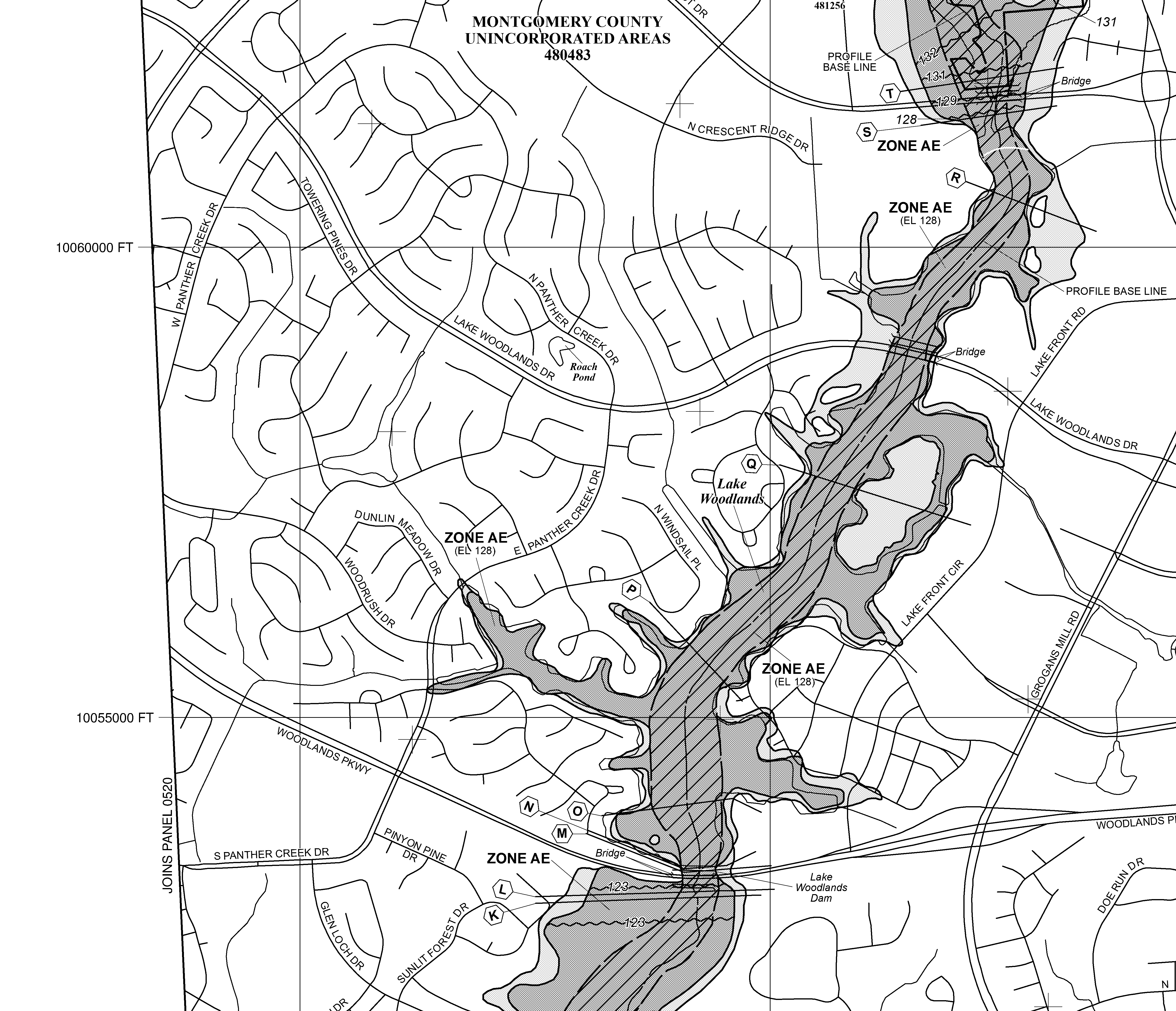
The effective parcel intersects shaded Zone X and Zone AE. Shaded X is horizontally within the mapped 0.2%-annual-chance hazard. The floor may be vertically above the modeled 0.2% water surface, but that remains conditional on a common datum and a site-specific professional determination.
New current-map warning: FEMA’s official draft database shows an in-review Montgomery County PMR, case 25-06-0037, published 9 July 2026. Its draft flood-zone layer classifies the subject point/parcel as Zone AE. It is not effective, preliminary, or pending regulatory data today, but it materially weakens any decision based on “old map comfort” and belongs in the civil PE’s review now.
Effective BFE
128.0′
Zone AE static BFE, NAVD88, effective NFHL.
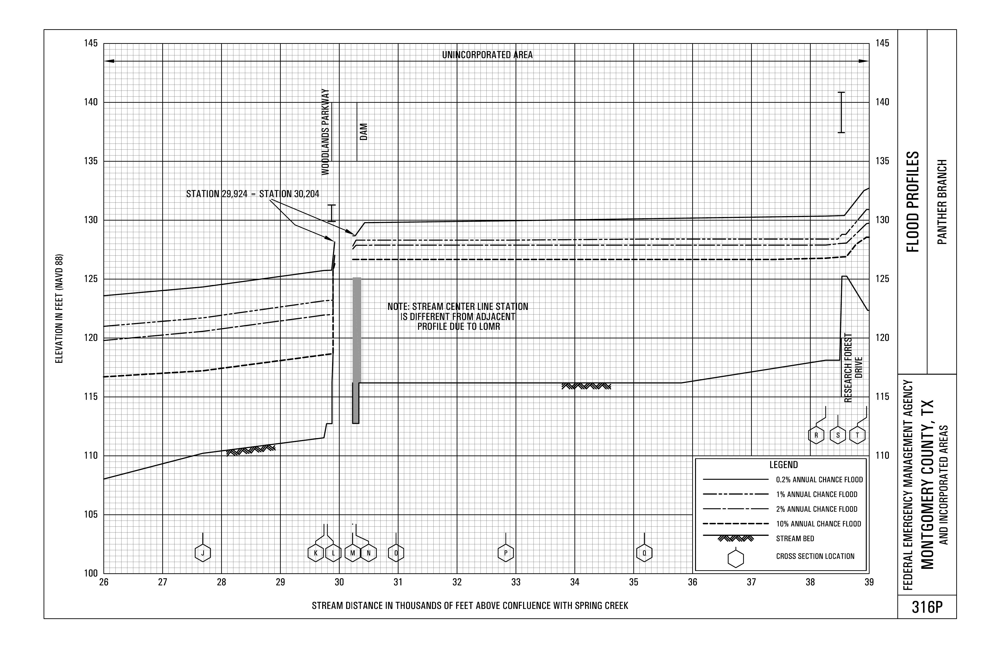
FIS 0.2% profile
≈130.0–130.2′
NAVD88 near the project reach; graph reading, not a certified site value.
Architectural R3
133.5′
Finished floor; vertical datum not stated.
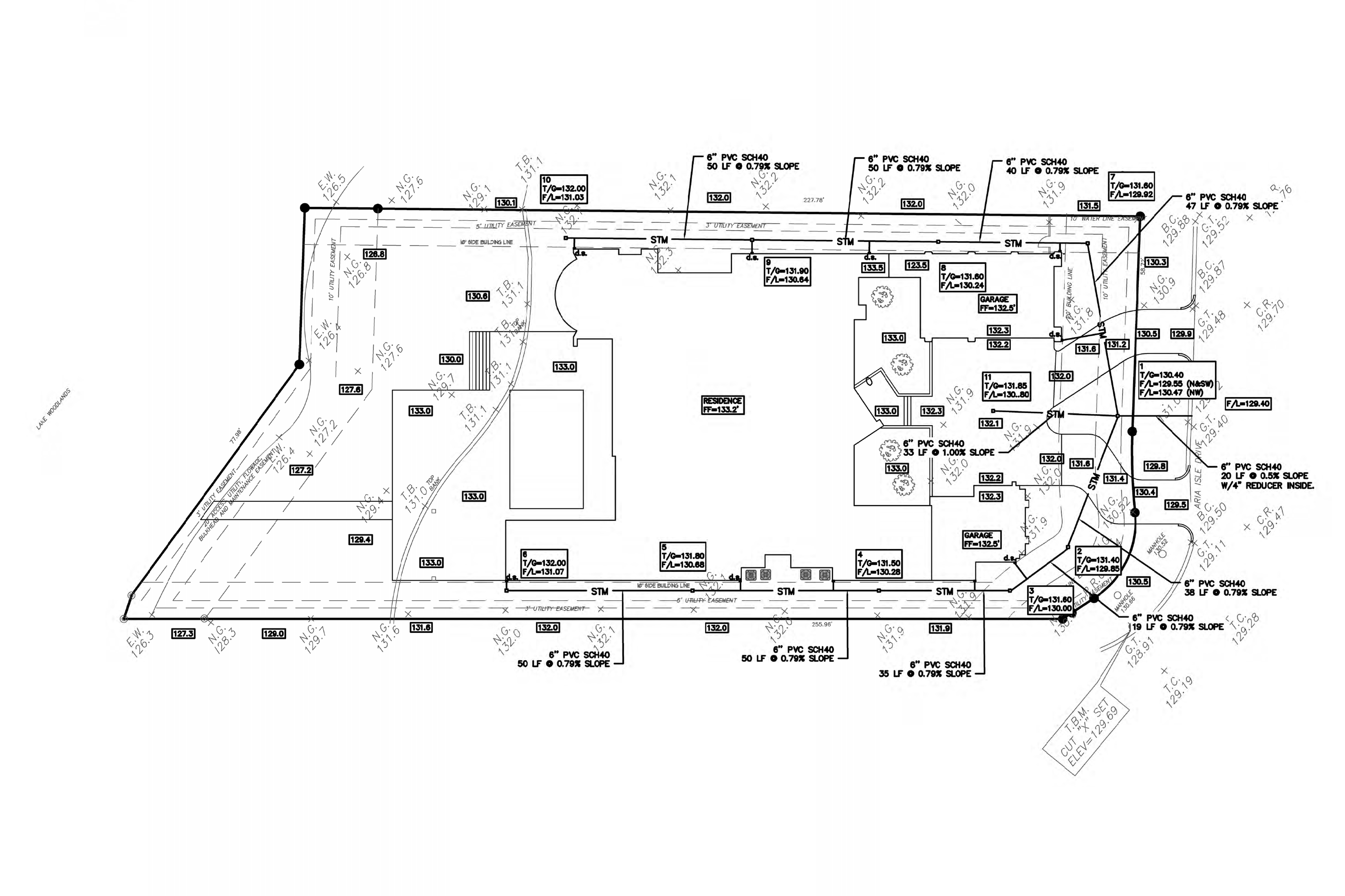
Approved civil C1.0
133.2′
Residence FF, NAVD88 / 2001 adjustment; 0.3 ft conflict with R3.
02 / ACTIONS
Pre-pour decision gates
The correct response is not to choose 133.5 or 134.5 from the call. It is to force every professional and reviewing authority onto the same coordinate/elevation control and then make a documented resilience decision.
Ultimate issues a narrow internal hold List the exact work affected and preserve permit status; ask County in writing about the permit’s one-week cessation language and the 22 September 2026 slab-pour deadline.
Ultimate · today
Independent Texas RPLS performs a sealed datum/benchmark crosswalk Recover project control, observe current NAVD88, identify datum/adjustment/epoch/geoid, document monument recovery, closures, raw observations, existing ground, top of form, and proposed floor.
Owner side · critical
Independent Montgomery County floodplain civil PE gives a written determination Effective and draft mapping, BFE, 100-ft trigger, 0.2% WSEL, drainage/no-adverse-impact, utilities, equipment, EC stages, and safe FFE in the RPLS datum.
Civil peer · critical
Dunaway civil and structural EORs reconcile and seal Resolve C1.0 133.2 versus A1.1 133.5, REV2 versus REV4 document control, foundation/fill/pile effects, and all revised sheets/calculations.
EORs · critical
Ultimate obtains written County Floodplain Administrator answers Do not rely on an oral “The Woodlands” instruction. Confirm panel/PMR, SFHA distance, minimum floor/equipment, required permit supplements, EC checkpoints, and hold-period status.
Permittee · critical
Architect and private design reviewer check height and grading Any raise can change the reported third-floor variance, 40-ft overall-height rule, entries, stairs, driveways, pool/deck, walls, and exterior drainage.
Architect / ESDC
Release one coordinated IFC set only Revision register, written change instrument, field benchmark sheet, distribution log, and subcontractor acknowledgments before construction resumes.
Ultimate · closeout
03 / CALL
What the conversation actually established
The Plaud share yielded a complete 93-segment machine transcript. Speaker 3—very likely Stephen—reported experience from another project. His statements are evidence of a warning, not sealed evidence of Lot 4’s elevation.
Time
Claim
Audit
01:28–02:26
Woodlands monuments no longer exist; island houses must follow its control; FF 133.5 is at/above the 500-year level.
Partly unresolved Legacy control concerns are credible. The universal requirement, authority, and site flood comparison were not produced.
06:14–07:11
130.96 local equals 127.98 “true,” a 2.98-ft delta.
Arithmetic only 130.96−127.98=2.98, but another project’s points cannot be transferred to Lot 4.
10:56–11:34
133.5 local equals 130.5 true, “basically” the 500-year level; all homes are 133.5 minimum.
Not verified Effective FIS graph is about 130.0–130.2 in the reach. No universal as-built FFE evidence was found.
12:09–13:59
Another project is 136.85 local / 133.85 true, “3.15 ft” above 500-year.
Internal mismatch 133.85−130.5=3.35, not 3.15.
13:59–15:59
Raise Lot 4 to 134.5; structural can adapt beams; County is easy.
Option, not design Raising a floor is civil, structural, architectural, utility, private-review, and permit work—not a field adjustment.
23:20–24:09
Reviewers may check form/top-of-floor and overall height.
Directionally supported Project guidelines require pre-concrete and final survey/inspection records.
26:43–31:30
Team asks why care if above 500-year; discusses civil/structural notification and benchmark at front.
Prudent question The correct next move is a common-datum professional reconciliation, not acceptance of the call’s answer.
Transcript fidelity
The stored transcript preserves Plaud wording, labels, gaps, and recognition errors. Speaker identities are inferred: Speaker 4 is very likely Kanti; Speaker 1 likely Murat; Speaker 3 very likely Stephen.
Plaud public share Displayed 2026-07-31 15:29:56 · 31m 33s · file ID 520fac…9022.
Preserved Markdown source retained in the local project record; not published.
04 / DATUM
The three-foot story: plausible cause, unproved conversion
The record contains several elevation “languages.” Numbers that look similar cannot be subtracted safely until a surveyor identifies the reference surface, realization/adjustment, observation epoch, geoid model, and point-to-point tie.
Confirmed
R2 used a suppressed NGS height
R2 cited BL1169 / R 88 at 121.76 ft NAVD88. The current NGS datasheet marks the NAVD88 orthometric height “NOT PUB” and flags suspected vertical motion. The suppressed historic value is exactly 121.76 ft.
Confirmed
This is not a normal datum conversion
The County FIS says its NGVD29→NAVD88 conversion is only +0.007 ft. At BL1169 the superseded NGVD29 and NAVD88 heights differ by about 0.01 ft. A three-foot issue points to stale realization, subsidence, assumed/local datum, or control error—not the datum names alone.
Inference
Why old control may persist
Continuity: plats, roads, drainage, utility inverts, and decades of approvals can share a local network. Relative slopes may remain internally useful even when absolute heights drift. That administrative benefit does not authorize mixing the local network with a current regulatory flood datum.
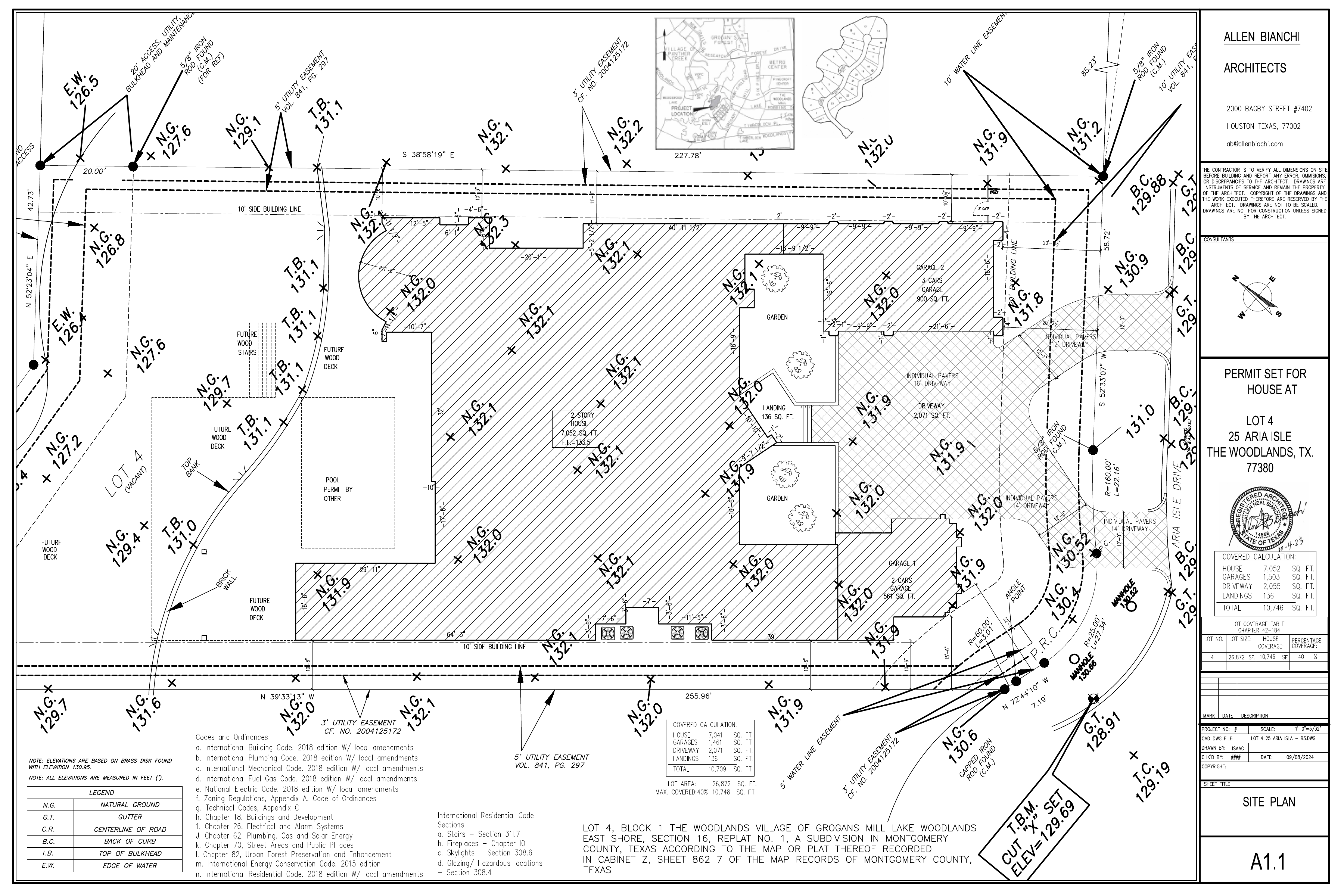
Architectural R3, A1.1: proposed F.F. 133.5; note says elevations are based on a found brass disk at 130.95, but does not disclose a vertical datum. This is what must be tied by a current RPLS.
05 / FLOOD
Is the home above the 500-year flood?
Answer: not yet verified. Horizontally, the address/footprint appears in effective shaded Zone X and a lakeward strip of the parcel intersects Zone AE. Vertically, 133.5 could provide substantial margin—or almost none—depending on its datum. A shaded-X location is not “outside the 500-year floodplain”; it is the mapped moderate-hazard area.
Terminology that will age well: say “the lowest floor is X feet above the adopted 0.2%-annual-chance water-surface elevation, both NAVD88,” once certified. Do not say “the property is above the 500-year floodplain.” A 0.2% event also has about a 5.83% chance of occurring at least once in 30 years and 11.32% in 60 years.
Scenario
Converted floor
Margin above effective BFE 128
Margin above FIS 0.2% ≈130.0–130.2
Meaning
Civil 133.2 is valid NAVD88
133.2 NAVD88
+5.2 ft
+3.0 to +3.2 ft
Comfortable modeled vertical margin; still reconcile the 0.3-ft plan conflict and exact site WSEL.
Architectural 133.5 is valid NAVD88
133.5 NAVD88
+5.5 ft
+3.3 to +3.5 ft
Supports the practical conclusion, but the R3 sheet does not disclose the datum.
Call’s −2.98-ft hypothesis
130.52 NAVD88
+2.52 ft
+0.32 to +0.52 ft
Meets a BFE+2 threshold by only ~0.52 ft if the County trigger applies; little 0.2% freeboard.
134.5 local under same hypothesis
131.52 NAVD88
+3.52 ft
+1.32 to +1.52 ft
A resilience option, not a recommendation until height, structure, drainage, utilities, and approvals are modeled.
The call also used an asserted 130.5-ft 0.2% WSEL. Against 130.5, the four vertical margins above become +2.7, +3.0, about 0.0, and +1.0 ft respectively. FEMA does not tabulate 130.5 for the site; the profile graph near the reach reads closer to 130.0–130.2. A PE must select the correct station/model.
Do not evaluate the residence floor alone. Civil C1.0 places both garages at 132.5. Under the call’s −2.98-ft hypothesis, that converts to about 129.52 NAVD88—roughly 0.48–0.68 ft below the effective-profile 0.2% curve and about 0.98 ft below the call’s asserted 130.5. Garage openings, depressed areas, equipment, utilities, and flood-entry paths need their own civil review.
Effective FIS Volume 5, profile 316P. The upper solid line is the 0.2%-annual-chance profile; the 1% line is near 128 ft through Lake Woodlands. Graph reading is approximate.Effective FIRM 48339C0540H (18 Aug 2014). Official parcel geometry—not visual inspection of this crop—shows both shaded X and AE intersect Lot 4.
Effective today
FIRM 48339C0540H, effective 18 Aug 2014.
Lot 4 intersects shaded X and AE; static BFE 128 NAVD88.
No effective LOMA point or LOMR polygon was found intersecting the parcel.
Project permit: if any portion of the structure is within 100 ft of SFHA, entire structure must be BFE+2.
Draft / future-facing
Official in-review PMR 25-06-0037, published 9 Jul 2026.
Draft flood-zone data classifies the parcel/address as AE / SFHA.
Draft nearby 1% WSELs: cross section O 127.3; P 127.8 NAVD88.
Not regulatory yet; nevertheless review model, timing, and design resilience now.
06 / DOCUMENTS
Rev4 and the project-control conflict
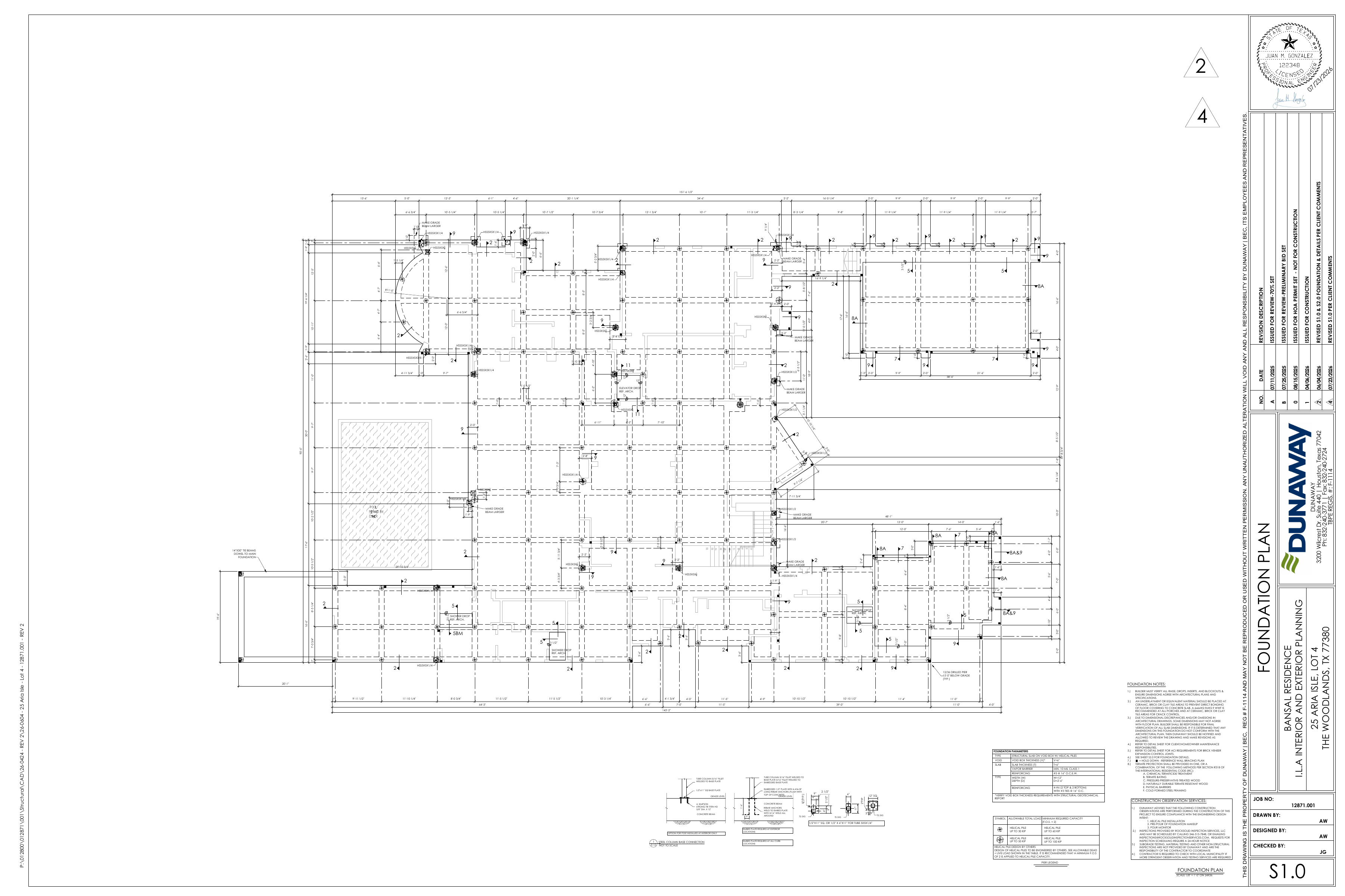
Email search found a structural REV 4 issued by Dunaway on 23 July 2026. The local “Current_Drawings” folder still contains structural REV 2 and architectural R3. REV4 does not state the project FFE or datum, so it cannot close this issue.
Document
What it says
Finding / action
Architectural R3 23 Jan 2026
F.F. 133.5; brass disk 130.95; TBM 129.69; datum absent.
Latest architectural set found. Tie all points to current NAVD88 and reconcile with civil.
Issued after Keystone/Dunaway grade-beam and detail clarifications; no FFE/datum callout.
Latest available, not automatically controlling. Ultimate/EOR/Keystone must issue written document-control direction and updated IFC register.
Structural REV 3
Materially changed foundation assembly to select-fill slab-on-grade.
Not interchangeable with REV2; do not claim REV2 and REV3 identical.
Survey R1 in Current_Drawings
63 Aria Isle, Lot 11—not 25 Aria/Lot 4; brass disk 130.95; no vertical datum.
Wrong-lot survey cannot support Lot 4 elevation control. Remove from active IFC use or watermark “reference only / wrong lot.”
Superseded architectural R2
BL1169 121.76 NAVD88; TBM 127.56; natural grades about 2.13 ft below R3.
Demonstrates provenance break; BL1169 height is now suppressed by NGS.
County permit SP-0055704-26
Ultimate as nontransferable permittee; zones AE/X shaded; 100-ft / BFE+2 condition.
Ultimate must obtain written County determination and any supplements before a changed pour.
KGW dirtwork contract
Rough grade about 132, 18 in below top slab 133.5.
Construction allocation only; not an elevation certification or flood determination.
Document-control rule: do not silently replace the approved/executed structural basis with REV4. REV4’s existence after the REV2 “freeze” is a source conflict that must be resolved, dated, sealed, issued, acknowledged, and—if required—resubmitted.
HOA-approved C1.0: Residence FF 133.2 and Garage FF 132.5. This sealed civil record is a direct conflict with architectural R3’s 133.5.Structural REV4 downloaded from email, issued 23 Jul 2026. SHA-256 c5d98b83…c8dd2e. No project FFE/datum appears.
Plan and email provenance
REV4 email: Open Archiver ID 34ef5426-8459-4ae9-b813-4b13095ea8a8, from JZimmermann@dunaway, subject thread issuing “REV 4” after 15 July grade-beam/detail clarifications.
Final architectural source: Open Archiver ID 90055fa1-83fa-4671-9b9f-3bef3829af15; R3, 32 pages, issued 23 Jan 2026.
HOA approved resubmittal: 9 Mar 2026 approval forwarded 17 Mar; local package includes the civil sheet described above.
REV4, architectural R3, structural REV2, and the full HOA package remain in the local project record; the source files are not published here.
07 / NEIGHBORS
An honest map of known—and unknown—FFEs
Only 25 Aria has a defensible numeric proposed FFE in the records found. No public, sealed as-built FFE was found for the surrounding homes. Spot grades are terrain, not floor elevations; the call’s “all houses are at least 133.5” is not a substitute.
If the embedded map does not load, open it in a new tab. Official MCAD parcel polygons provide geometry/status; FEMA supplies flood polygons. Map labels do not infer FFEs.
Request County/owner ECs or sealed as-builts; do not estimate from LiDAR.
Verified subdivision-control clue
Developer-posted Lot 5 and Lot 14 surveys use TC-38 = 143.88 ft, NGVD29 1964 Adjustment. The recorded plat identifies a brass disk stamped “ESL-16 R1,” elevation 134.92, printed “NAVD 29, 64 ADJ.” This verifies legacy control language; it does not tie R3’s 130.95 disk to current NAVD88.
How to obtain real neighbor FFEs
Ask Montgomery County for any public elevation certificates/form surveys by address or permit, ask the private reviewer/developer for accepted slab-height surveys, and use owner-provided as-builts. A Texas RPLS can also survey visible floors with permission. Label every value by source, date, datum, and certification status.
08 / ROLES
What this means for the homeowner and builder
Capacity matters: you described yourself as the builder. The formal project record identifies Ultimate Homes USA, LLC as GC and nontransferable County permittee; Arjun Shiva Investments LP is Owner; REJAK, LLC is owner-side administrator/direct counterparty for its own contracts, not the GC. Communications and approvals should state the signer’s actual capacity.
Party
Current role
Elevation/flood responsibility now
Arjun Shiva Investments LP
Owner / title holder
Approves risk/cost choices; receives property-level consequences; ensures financing/insurance/disclosure decisions are informed. County noncompliance can affect the property.
Ultimate Homes USA, LLC
GC and County permittee
Controls hold/release, plan distribution, County submissions/supplements, inspection/EC sequencing, field compliance, and trade coordination.
REJAK, LLC
Owner-side administrator; direct counterparty where named
Coordinates within its contracts, preserves records, routes owner decisions, and avoids purporting to bind Owner or Ultimate without authority.
Kanti / Shanti / Murat
Individuals with project/consultant communications or contracts
State capacity; route notices through the actual contracting client. Dunaway’s agreement is reportedly with Kanti/Shanti personally; STSA proposal is signed/invoiced to Murat personally.
RPLS / civil / structural / architect
Licensed design/measurement professionals within scope
Each owns a different question. Do not let a structural answer substitute for datum/flood/drainage work or an RPLS measurement substitute for civil design.
Homeowner implications
Shaded X is moderate risk, not “no flood risk”; a strip is effective AE and draft mapping is more conservative.
Insurance/lender pricing can use first-floor height and property-level data; coverage remains policy-specific.
Even a high floor does not solve access, yard/pool, drainage, equipment, sanitary sewer, or utility interruption.
Future maps and continuing subsidence can change perception, pricing, and disclosure questions.
Builder / permittee implications
Build the approved coordinated set; obtain written approval before elevation changes.
Verify form/slab height and datum before concrete; complete required EC/as-built stages.
Document RFIs, decisions, plan distribution, and trade acknowledgments; do not make unsupported flood representations.
09 / TEAM
Who must know—and whether to hire a second civil expert
Yes: tell civil and structural immediately, in writing. But a “second civil” alone is incomplete. Hire an independent Texas RPLS for the measurement/control question and an independent floodplain civil PE familiar with Montgomery County for the regulatory/hydraulic/drainage question. Keep the structural EOR responsible for foundation consequences.
Independent RPLS scope
Recover all cited monuments/TBMs.
State current datum, realization/adjustment, epoch, geoid, units.
Use current GNSS/OPUS/level loop appropriate to tolerance.
Provide raw observations, closures, photos, descriptions.
Crosswalk R2/R3/C1.0/project/local/FEMA values.
Seal existing ground, top-of-form, and floor deliverables.
Independent civil PE scope
Effective FIRM/FIS and draft PMR/model.
AE boundary and 100-ft measurement.
Adopted BFE and defensible 0.2% WSEL.
Minimum floor/equipment and resilience target.
Grading, no adverse impact, walls, lake interface.
Private reviewer: slab-height and final compliance.
Ultimate: County and field execution.
Independence: for a decision this consequential, use a peer who did not originate the questioned survey/civil design and is not being asked merely to defend it. If a claim is reasonably foreseeable, Texas construction counsel may retain the reviewer for legal advice/privilege strategy—but safety and permit facts still must be disclosed where required.
10 / WHY
Why legacy control persists—and the headaches it creates
Evidence-backed inference
Likely reasons, without accusing motive
Network continuity. Roads, utility inverts, drainage, plats, and design approvals were built in one local frame.
Repeatability. A physical/local TBM can reproduce relative construction geometry even when the national height changes.
Reissue cost. Updating decades of plans, easements, and databases is expensive and introduces transition errors.
Fragmented authority. “The Woodlands” may mean developer/private reviewer, Township, utility district, or County. The Township says it lacks direct drainage authority.
Subsidence lag. Releveling old networks was costly; Houston-area practice moved toward GPS monitoring as ground movement made static published heights harder to maintain.
No evidence supports the call’s theory that the system was knowingly chosen to sell flood-prone property.
Future risk
Where mismatched systems bite
Concrete and height: slab misses permit/private-review target or architectural maximum.
Drainage: swales, walls, pool deck, lake edge, and neighbors operate in the wrong vertical frame.
Sanitary/storm: slopes and inverts lose capacity; a higher floor does not automatically fix every downstream elevation.
Certification: form survey, final EC, as-built, County file, insurer, lender, and resale package disagree.
Claims: consultants and trades point at scope exclusions, superseded sheets, and undocumented field instructions.
Future mapping: the July 2026 draft AE mapping may become more important even if today's effective map is unchanged.
11 / PROTECTION
How to protect the project legally
Legal protection comes from acting reasonably after receiving the warning: preserve evidence, notify the right parties neutrally, obtain licensed determinations, comply with permit/private approvals, and keep one traceable construction record. It does not come from an owner waiver or from repeating an accepted local number after learning it may be incomparable.
Record and notice controls
Preserve the recording/share, exact transcript, emails, drawings, permits, surveys, raw observations, site photos, benchmark photos, and field logs.
Do not alter/backdate old signed records. Issue dated supplements, amendments, RFIs, and revised sealed plans.
Send a neutral potential-discrepancy notice through the actual contract clients and capacities; follow contractual notice/cure provisions.
Maintain a revision register and documented IFC distribution; collect trade acknowledgments.
Put time/cost/scope changes in signed instruments between the correct entities.
Counsel and insurance controls
Have Texas construction counsel review consultant limitation/cure clauses, residential contract Chapter 27 notice, warranties, and repose terms.
Texas Property Code §27.003’s official-record defense is knowledge-qualified; after this warning, blind reliance is harder to defend.
Review builder’s-risk, CGL, flood, and professional-liability notice requirements; a certificate is not the policy.
Do not promise buyers/lenders/insurers “above 500-year” until the statement is professionally defined and certified.
Future disclosure is counsel-specific; new-home exemptions are not permission to conceal or misstate a known material condition.
Draft neutral notice — not sent
SUBJECT: 25 Aria Isle — potential vertical-control discrepancy; request for sealed reconciliation

During a 31 July 2026 project call, the team received an unverified report that legacy/local elevation control used for Aria Isle may differ materially from current geodetic elevation control. Our current records also show: (1) architectural R3 F.F. 133.5 with no stated vertical datum; (2) approved civil C1.0 Residence FF 133.2 on NAVD88/2001 adjustment; (3) a wrong-lot survey in the active folder; (4) effective FEMA AE and shaded-X mapping on Lot 4; and (5) a July 2026 in-review draft PMR affecting the parcel.

This notice does not adopt the reported three-foot offset and does not accuse any party of error. It requests preservation of relevant records and a written, sealed, coordinated determination.

Please provide, within your actual scope: the controlling benchmark(s), datum/adjustment/epoch/geoid, monument recovery and raw observation/closure information; a point-by-point crosswalk among project drawings and FEMA/County criteria; the controlling FFE; required permit/private-review supplements; and the structural, civil, drainage, utility, and architectural consequences of any change.

Ultimate Homes USA, LLC, as GC/permittee, should identify the precise internal hold and release it only after receiving the required licensed determinations and written authority approvals. No party should rely on this draft as a stop-work order, design change, or authorization to proceed.
Draft only. It has not been sent. Counsel should tailor recipients, contractual notice methods, deadlines, reservations, and capacity language.
Questions Ultimate should put to Montgomery County
01
Which effective panel, FIS profile/station, LOMRs/LOMCs, and July 2026 draft PMR materials should the design team review?
02
What BFE and vertical datum govern Lot 4, and what survey/control evidence will County accept?
03
Does any portion of the proposed structure fall within 100 ft of the SFHA, and how exactly is the distance measured?
04
What minimum lowest-floor and machinery/equipment elevations apply?
05
Which form, under-construction, and final Elevation Certificate or as-built checkpoints are required?
06
Does 133.2, 133.5, or a contemplated 134.5 comply after tying the project benchmark to the governing datum?
07
Which structural/nonstructure permit supplements and private approvals must be complete before pouring?
08
Will County confirm permit status during this review, given the permit’s 180-day and “cessation over one week” wording?
L30 / SIGNAL
What people are saying now
🌐 last30days v3.18.3 · synced 2026-07-31
The recent public signal supports investigating regional subsidence; it does not validate the Lot 4 conversion. July coverage says Houston-area communities, including The Woodlands, remain under active subsidence monitoring. Current professional guidance consistently stresses common-datum comparisons and repeatable control.
Useful signal
Regional subsidence is current, not historical trivia. Houston-area authorities explain why old benchmark networks needed releveling and later GPS monitoring.
Weak social evidence
The targeted 30-day run found little direct discussion of construction datum conflicts. Many high-engagement X/HN/GitHub hits were irrelevant; do not mistake volume for technical consensus.
Coverage limits
Reddit, X, HN, GitHub, and web returned data. TikTok, Instagram, and YouTube failed with provider HTTP 402 in this run, so their silence cannot be interpreted as no discussion.
Primary government data and sealed project records control the conclusions. Practitioner/social material is contextual only. Private project source files remain in the local project record and are not published on this site.
HOA package SHA-256: fa5d7e5f6b104d32052a03799948903e06158eeb9425f9a5d40955096e77f063.
No taxpayer IDs, policy numbers, or bank information are reproduced here.
No external email, notice, or message was sent.
13 / TRANSCRIPT
Complete transcript & claim ledger
The full standalone transcript includes all 93 segments, speaker-recovery confidence, a line-by-line verification ledger, numeric audit, and follow-up evidence requests.